
Home \ Blog \ Bathymetric Survey in UAE: Singlebeam or Multibeam
Bathymetric Survey in UAE: Singlebeam or Multibeam
September 7, 2026

Most tenders for a Global Map Survey’s multibeam and singlebeam bathymetric surveys page name a sensor before they name a requirement. That is the wrong way round. Singlebeam and multibeam answer different questions at different prices, and choosing between them is a decision about coverage and consequence rather than about technology. This guide sets out what each method actually delivers, where the accuracy comes from, what drives cost in Gulf conditions, and how to write a specification that gets you the survey your project needs instead of the one that was cheapest to quote.
Key Takeaways
- Singlebeam measures depth along survey lines. Multibeam measures a continuous surface. If the thing you are looking for could sit between two lines, you need multibeam.
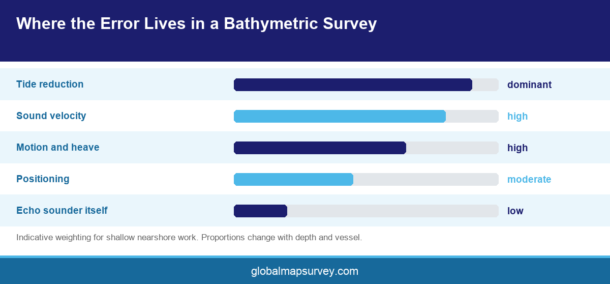
- Accuracy in a bathymetric survey comes from tide reduction, sound velocity control and motion compensation far more than from the echo sounder itself.
- Specify the deliverable and the confidence you need, then let the surveyor select the sensor. Naming the sensor first often buys coverage you do not need or misses coverage you do.
What Each Method Actually Delivers
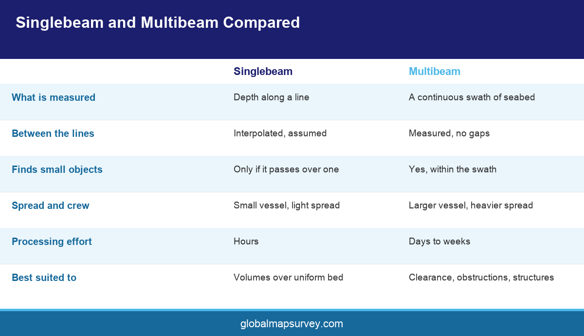
A singlebeam echo sounder emits one narrow pulse straight down and times its return. Run along a planned line, it produces a profile of depth beneath the track. Cover an area with parallel lines at a fixed spacing and you get a set of profiles that a software package interpolates into a surface. The critical word is interpolates. Between the lines, the model is an assumption.
Multibeam sweeps a fan of beams across the track, so a single pass measures a swath of seabed rather than a line. Overlap the swaths and the result is a continuous, fully ensonified surface with no gaps and no interpolation. The difference in what a multibeam system records is not a refinement of the same measurement. It is a different class of data.
That distinction decides most projects. A dredging progress volume across a flat, uniform basin is answered perfectly well by singlebeam lines at sensible spacing. A search for a dropped object, a pipeline crossing, a scour hole at a quay wall or an obstruction in a navigation channel is not, because those features are smaller than the line spacing and the interpolation will simply erase them.
Cost follows the same logic. Singlebeam is cheaper to mobilise, needs a smaller vessel and a smaller crew, and processes faster. Multibeam carries a heavier spread and a much larger processing effort, and it will find things nobody expected, which is either the point of the survey or an expensive surprise depending on the scope.
Where the Accuracy Really Comes From
Owners tend to assume the echo sounder sets the accuracy. In practice the sounder is rarely the weakest link. Four corrections dominate the error budget, and a survey is only as good as the weakest of them.
Tide reduction converts a measured depth below the transducer into a depth relative to chart datum. In the Arabian Gulf the tidal range is modest but the residual, driven by wind and barometric pressure, is not negligible, and a survey reduced against a distant gauge inherits that difference as a systematic error. Local tidal observation at or near the site is the fix, and on larger sites more than one gauge is warranted.
Sound velocity governs how a travel time becomes a distance. Gulf water is warm and saline, and both vary with depth, season and proximity to a discharge. A sound velocity profile taken once at the start of a hot day and reused all week will bend the outer beams of a multibeam swath into visible smiles or frowns. Profiles should be taken often enough that the water column has not meaningfully changed between them.
Motion compensation and positioning complete the set. Heave, pitch, roll and heading must be measured at the transducer and applied in real time, and horizontal position needs a correction service good enough for the tolerance being claimed. Standards published by the International Hydrographic Organization define order classes that bundle these requirements together, which is why specifying an IHO order is more useful than specifying an instrument.
Choosing for the Job in Front of You
Start from the decision the data has to support. If the answer is a volume, ask how much money a one percent error is worth. On a large capital dredging campaign that error is significant enough to justify full coverage. On a small maintenance dredge it is not.
If the answer involves safety of navigation or the integrity of a structure, full coverage is usually the only defensible choice. A pre and post dredging bathymetric survey for a berth that will take deep draught vessels has to prove there is nothing left on the bed, and lines cannot prove absence.
Water depth and seabed character shift the balance too. In very shallow nearshore water a multibeam swath is narrow, so line spacing tightens and the cost advantage of full coverage shrinks. Over rock, coral or heavily scoured ground the interpolation between singlebeam lines becomes much less trustworthy, which pushes the other way.
There is a middle path that is often overlooked. Running singlebeam across the bulk of an area and multibeam over the parts that matter, such as structure surrounds, channel edges and known obstruction zones, delivers most of the confidence at a fraction of the full coverage cost. It needs to be planned deliberately rather than improvised, and it needs the boundaries agreed before mobilisation.
Writing a Specification That Works
A good bathymetric specification states six things. The purpose of the survey. The datum, both vertical and horizontal, with the transformation named. The required order or accuracy class. The coverage requirement, expressed as full coverage or as line spacing. The deliverable formats. And the acceptance criteria, including crossline agreement.
Datum deserves a line of its own because it causes more rework than any other clause. Marine work in the Emirates is usually reduced to a chart datum tied to a local tide gauge, while the land side of the same project sits on a national or project grid. Those two are not the same surface, and the offset between them is not a constant across a large site. Name both datums in the specification, name the transformation, and require the surveyor to state which one every deliverable is on. Reclamation projects that join a bathymetric model to a topographic one without doing this routinely discover the problem at the point where the two surfaces are supposed to meet.
Crossline checks deserve emphasis because they are the internal proof of the survey. Lines run perpendicular to the main pattern should agree with it inside a stated tolerance, and the report should show that comparison rather than assert it. A survey delivered without a crossline analysis has not demonstrated its own accuracy.
Ask for the raw data alongside the processed surface. Sound velocity profiles, tide records, calibration results and navigation logs let an independent reviewer reconstruct the reduction. On projects where the volume feeds a payment certificate, that reviewability is worth more than any presentational polish on the charts.
One clause is worth adding to every marine scope in the Gulf. Require the surveyor to record and report the weather and sea state under which each line was run. Short period chop degrades a multibeam swath in ways that survive processing, and a shamal that closes the site for three days changes the programme. A record of conditions costs nothing to keep and settles most later arguments about why one block of data is noisier than the rest.
Conclusion
A bathymetric survey in UAE is a measurement chain, and the echo sounder is only one link in it. Decide first whether your project can tolerate assumptions between survey lines. If it can, singlebeam is efficient and entirely defensible. If it cannot, pay for full coverage and do not dilute it. Then put the effort where the error actually lives, in tide reduction, sound velocity and motion, and insist on crossline evidence in the report. To scope a bathymetric survey for a berth, channel or reclamation in the Emirates, contact the Global Maps Survey hydrographic team.
AN ISO 9001-2015 CERTIFIED COMPANY