Home \ Blog \ 3D Scanning Services in Abu Dhabi: A Complete Guide
3D Scanning Services in Abu Dhabi: A Complete Guide
May 21, 2026
3D Scanning Services in Abu Dhabi are reshaping how construction companies, engineers, and infrastructure developers capture spatial data. Whether you are planning a large-scale infrastructure project or a complex engineering survey, precise 3D scanning technology delivers the accuracy modern projects demand. In this guide, you will learn what 3D scanning involves, how it supports construction and engineering workflows, and why partnering with a professional 3D Modeling Company in UAE can elevate your project outcomes significantly.
Key Takeaways
- 3D Scanning Services in Abu Dhabi provide high-accuracy spatial data that supports construction, infrastructure, and engineering project planning.
- 3D Scanning Services in UAE are widely adopted by civil engineers, architects, real estate developers, and government infrastructure departments.
- Choosing a professional 3D Modeling Company in UAE ensures that captured scan data is processed into actionable models for design, analysis, and documentation.
What Are 3D Scanning Services and Why Do They Matter?
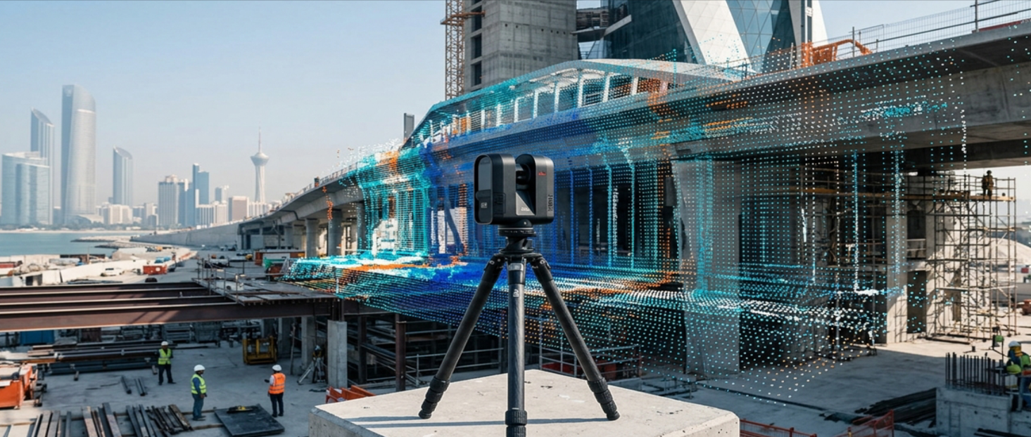
3D scanning is the process of capturing the physical shape and dimensions of real-world objects, structures, or environments using laser or photogrammetry-based technology. The result is a highly detailed point cloud or 3D model that represents the scanned subject with precise measurements.
In Abu Dhabi, where large-scale construction and infrastructure development are constant, the demand for 3D Scanning Services in Abu Dhabi has grown steadily. These services eliminate guesswork from project planning and provide engineers with verified spatial data before any design decision is made. According to global infrastructure consultants, accurate as-built documentation reduces costly errors during construction by a significant margin.
For developers and project managers, this means fewer surprises on site, faster approvals, and better coordination between design teams. The value of 3D scanning lies not just in the data it captures, but in the decisions it enables. Learn more about how professional survey and spatial data services in the UAE support informed project decision-making at every stage.
Key Applications of 3D Scanning Services in UAE Construction Projects
The construction and engineering sectors across the UAE rely on 3D scanning for a wide range of project types. From heritage site documentation to new infrastructure builds, the technology adapts to diverse project requirements.
As-Built Documentation and Facility Management
One of the most common uses of 3D Scanning Services in UAE is capturing accurate as-built conditions of existing structures. When a building is modified, extended, or repurposed, engineers need a verified record of the current state. 3D scanning provides that record with millimeter-level detail. This supports renovation planning, MEP coordination, and facility management over the lifecycle of the structure. Many civil engineering firms in Abu Dhabi now require as-built scans before any modification work begins to avoid clashes and design conflicts.
Topographic and Site Surveys for Land Development
Before any construction begins, a thorough understanding of the site terrain is essential. 3D scanning technology complements traditional topographic survey methods by capturing detailed surface data quickly and efficiently. The resulting 3D terrain models help engineers assess drainage, slope stability, and earthwork volumes with far greater precision than conventional survey methods alone. Real estate developers and infrastructure planners in Abu Dhabi use this data to make informed decisions about site feasibility and design layout from the earliest project stages. Explore how topographic survey services in Abu Dhabi integrate with 3D scanning workflows to deliver comprehensive site data.
Heritage Documentation and Cultural Site Preservation
Abu Dhabi has a rich cultural and architectural heritage. 3D scanning plays an important role in documenting historical structures, ensuring that accurate digital records are preserved for restoration and conservation purposes. Scanning these sites creates permanent digital archives that can be referenced by architects and conservationists without disturbing the physical structure. This application is growing across the UAE as awareness of cultural preservation increases alongside rapid urban development.
Industrial Plant and Infrastructure Inspections
3D Scanning Services in Abu Dhabi allow engineers to capture the geometry of complex industrial environments safely and quickly. The resulting models support clash detection, maintenance planning, and upgrade design for oil and gas facilities, industrial plants, and utility infrastructure. Compared to manual measurement methods, 3D scanning reduces the time spent on site and minimizes exposure to potentially hazardous environments. This makes it a preferred choice for facility managers overseeing large-scale industrial assets across the UAE.
How a Professional 3D Modeling Company in UAE Adds Value
Capturing raw scan data is only the first step. The real value comes from processing that data into usable models, drawings, and reports. A skilled 3D Modeling Company in UAE takes point cloud data and transforms it into BIM-ready models, 2D drawings, or detailed visualizations that engineers, architects, and project managers can work with directly.
Professional firms bring expertise in scan-to-BIM workflows, which are increasingly required on large commercial and government projects in Abu Dhabi. They ensure that models meet project specifications, coordinate across disciplines, and integrate with existing design software platforms such as Revit, AutoCAD, and Civil 3D.
Working with an experienced provider also means that quality control processes are applied throughout the data capture and processing workflow. This reduces the risk of errors in the final deliverables and ensures that the spatial data you receive is reliable and project-ready. According to Autodesk construction industry research, scan-to-BIM adoption is increasing globally as project owners recognize the long-term value of accurate digital asset records.
Choosing the Right 3D Scanning Partner for Your Project
Selecting the right provider for 3D Scanning Services in Abu Dhabi requires careful consideration of several factors. Not all scanning companies offer the same level of expertise, technology, or deliverable quality.
- Technology and equipment: Confirm that the provider uses current scanning hardware capable of delivering the resolution your project requires.
- Industry experience: Look for a team with demonstrated experience in your project type, whether construction, industrial, or heritage.
- Deliverable formats: Ensure the provider can deliver outputs compatible with your design and engineering software.
- Data processing capability: A provider that handles both scanning and modeling in-house reduces handoff errors and speeds up delivery timelines.
- Understanding of local regulations: In Abu Dhabi, certain survey and spatial data activities may require compliance with local authority requirements. Your provider should be familiar with these obligations.
Firms offering 3D Scanning Services in UAE that combine field scanning expertise with strong data processing capabilities are best positioned to support complex, multi-discipline projects. Visit Global Map Survey to discuss your project requirements with a team experienced in UAE construction and infrastructure scanning.
The Role of 3D Scanning in Supporting Geospatial Survey Workflows
3D scanning does not operate in isolation. It integrates naturally with broader geospatial survey workflows that include land surveying, boundary surveys, and engineering surveys. When combined with GPS-based positioning and traditional survey control networks, 3D scanning produces spatially accurate models that align with real-world coordinate systems.
This integration is particularly valuable on large infrastructure projects where multiple survey disciplines contribute data. A coordinated approach ensures that all spatial data, from topographic surveys to as-built scans, aligns within a common reference framework. This reduces coordination errors and produces a consistent, reliable spatial dataset for the entire project team.
Professional surveying and mapping firms that manage data integration across all survey disciplines provide a significant advantage by streamlining workflows and improving the accuracy of final deliverables for construction, infrastructure, and land development projects throughout Abu Dhabi and the wider UAE.
Conclusion
3D Scanning Services in Abu Dhabi are a powerful tool for construction companies, engineers, and infrastructure developers who need accurate spatial data to support their projects. From as-built documentation to topographic surveys and industrial inspections, the applications are broad and the benefits are clear. As demand for precision and efficiency continues to grow across the UAE built environment, investing in professional 3D scanning and modeling services is a smart and practical decision. If you are planning a construction, engineering, or land development project and need reliable spatial data, connect with Global Map Survey, a qualified 3D Modeling Company in UAE, to explore how these services can support your goals and deliver the accuracy your project demands.
FAQ
Q1: What are 3D Scanning Services in Abu Dhabi used for?
Answer: 3D Scanning Services in Abu Dhabi are used for as-built documentation, topographic surveys, heritage site preservation, industrial inspections, and construction planning. They capture precise spatial data that supports design, engineering analysis, and project coordination across multiple disciplines in the UAE.
Q2: How does 3D scanning improve construction project accuracy?
Answer: 3D scanning captures millimeter-level measurements of existing structures and terrain, reducing errors in design and construction. It provides verified spatial data that helps engineers detect clashes, plan modifications, and produce accurate as-built records, significantly reducing rework costs on construction projects in Abu Dhabi.
Q3: What is the difference between 3D scanning and traditional surveying?
Answer: Traditional surveying captures discrete measurement points, while 3D scanning captures millions of data points simultaneously to create detailed point clouds. This produces far more comprehensive spatial records in less time, making it a preferred approach for complex construction and infrastructure documentation projects across the UAE.
Q4: What industries use 3D Scanning Services in UAE?
Answer: 3D Scanning Services in UAE are used by the construction, oil and gas, real estate, heritage conservation, infrastructure, and civil engineering industries. Any project requiring accurate spatial documentation of existing or new structures benefits from professional 3D scanning and modeling capabilities available in Abu Dhabi.
Q5: What is scan-to-BIM and why is it important?
Answer: Scan-to-BIM is the process of converting 3D scan point cloud data into a Building Information Model. It is important because it produces accurate digital representations of real-world conditions, enabling better design coordination, clash detection, and facility management throughout the lifecycle of construction projects in Abu Dhabi.
Q6: How long does a typical 3D scanning project take in Abu Dhabi?
Answer: The duration depends on the size and complexity of the project. Small building scans may be completed in a few hours, while large industrial facilities or infrastructure sites may require several days of data capture followed by processing time. Professional firms typically provide project-specific timelines after an initial site assessment.
Q7: Can 3D scanning be used for outdoor terrain and land surveys?
Answer: Yes, 3D scanning integrates well with outdoor terrain capture for land and topographic surveys. When combined with GPS positioning and traditional survey control, it produces georeferenced terrain models that support earthwork calculations, drainage planning, and site feasibility assessments for land development projects in Abu Dhabi.
Q8: What deliverables can I expect from a 3D Modeling Company in UAE?
Answer: A professional 3D Modeling Company in UAE typically delivers point cloud data, BIM-ready models, 2D floor plans and elevations, section drawings, and 3D visualizations. Deliverable formats are usually compatible with industry-standard software such as Revit, AutoCAD, and Civil 3D to integrate with your existing project workflows.
Q9: Is 3D scanning suitable for heritage and historical site documentation?
Answer: Absolutely. 3D scanning is one of the most effective methods for documenting heritage and historical structures non-invasively. It creates permanent, highly detailed digital records that architects and conservationists can use for restoration planning and conservation projects across Abu Dhabi as cultural preservation awareness increases.
Q10: How do I choose the right provider for 3D Scanning Services in Abu Dhabi?
Answer: Choose a provider with proven experience in your project type, current scanning technology, strong data processing capabilities, and familiarity with local regulatory requirements. Firms that offer integrated scanning and spatial data services alongside 3D modeling can deliver more coordinated and reliable project outcomes across Abu Dhabi.
AN ISO 9001-2015 CERTIFIED COMPANY