WELCOME TO GLOBAL MAPS SURVEY
Headed by a team of Survey experts who is having experience in the industry for a decade, GMSS has been recognized as one of the premier company capable of managing all kinds of surveying requirements including oil fields services.
Topographic Survey

We provide topographic mapping services that helps in route planning, thematic data preparation, and decision-making for telecom and transport services and disaster management. Our services include creating comprehensive topographic maps and 3D topographic maps to the specified projection parameters, including generating contours.
We are dedicated to complete the works with in the stipulated time without compromising the accuracy in the works. Our quality control team ensures the quality of all the data before delivering them to our clients.
Utility Surveys

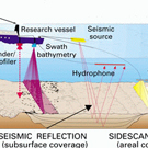
Hydrographic Survey
Traffic Surveys

Demarcation Surveys

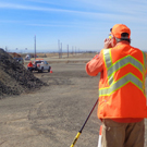
Stock Pile Volumes
3D Scanning

GIS
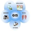
We offer output for all types of survey works in GIS based map formats where the end user is offered the flexibility to dive into the making of the map and connected features, querying, modeling, analysis etc.
AN ISO 9001-2015 CERTIFIED COMPANY