Home \ Blog \ AI in Underground Utility Detection- GPR Survey Services Guide
AI in Underground Utility Detection- GPR Survey Services Guide
May 21, 2026
Underground Utility Detection (GPR Survey) is one of the most critical steps in any construction or infrastructure project. When ground-penetrating radar combines with artificial intelligence, it becomes a powerful tool that helps engineers locate buried utilities with greater speed and accuracy. Whether you are working on a major infrastructure development or a routine excavation, understanding how AI enhances GPR Survey Services can protect your project from costly mistakes and dangerous utility strikes.
Key Takeaways
- Underground Utility Detection (GPR Survey) uses ground-penetrating radar to locate buried pipes, cables, and conduits without excavation, protecting worker safety and project timelines.
- AI-powered GPR analysis improves detection accuracy, reduces manual interpretation errors, and speeds up reporting for land surveying projects.
- Global Maps Survey Services, as professional Land Surveying Company in UAE can integrate GPR survey data with topographic and engineering surveys for comprehensive site intelligence.
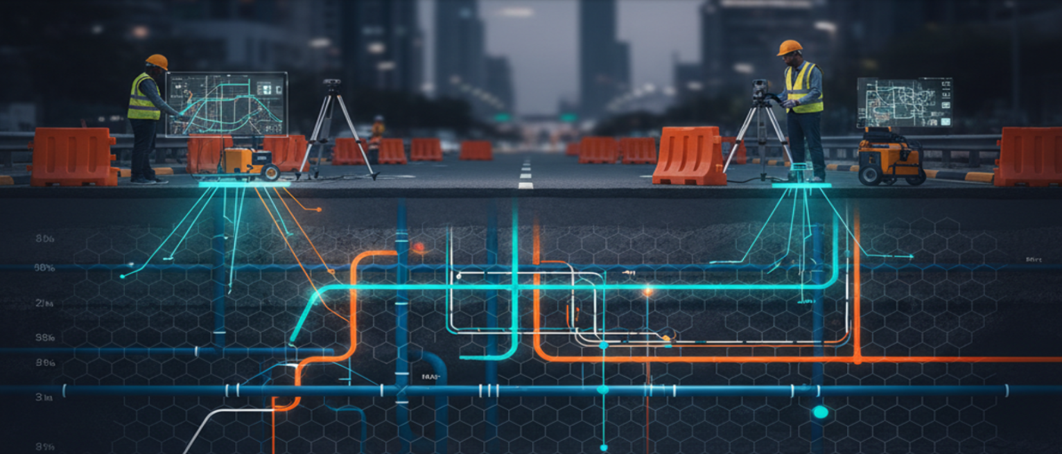
What Is Underground Utility Detection and How Does GPR Work?
Ground-penetrating radar is a non-destructive geophysical method that sends electromagnetic pulses into the ground and measures how those pulses reflect off subsurface objects. When a radar pulse hits a buried pipe, cable, or conduit, it bounces back at a detectable frequency. The GPR equipment records these reflections, and surveyors interpret the resulting data to map underground features accurately.
Traditional utility detection relied heavily on manual records, service drawings, and trial excavations. These approaches were time-consuming and often inaccurate. GPR survey services eliminate much of that uncertainty by providing real-time subsurface imagery. For projects managed by a professional land surveying company, integrating GPR into the survey workflow means faster data collection and more reliable spatial information for engineers and project managers.
According to the United States Department of Transportation, utility strikes during excavation remain a leading cause of project delays and worker injuries globally. GPR survey services directly address this challenge by giving teams a clear underground picture before any digging begins.
How AI Is Transforming GPR Survey Data Interpretation
AI adds a significant layer of intelligence to GPR survey services by automating the interpretation of complex radar waveform data. Traditionally, reading GPR outputs required experienced technicians who could spend hours analyzing hyperbolic reflections in radargrams. AI algorithms trained on large datasets of subsurface imagery can now identify utility signatures in seconds, flagging pipes, cables, voids, and other features with high confidence.
Machine learning models used in modern GPR analysis can distinguish between utility types based on signal shape, depth, and material properties. For example, a metallic conduit produces a different radar signature than a plastic water pipe. AI can classify these differences automatically, reducing human error and ensuring more complete utility mapping. This capability is especially valuable for a Land Surveying Company in Abu Dhabi operating in densely developed urban environments where underground infrastructure is complex and varied.
Deep learning approaches also allow GPR systems to filter out background noise and soil clutter, which are common sources of misinterpretation in raw radar data. The result is cleaner, more actionable subsurface maps that project teams can trust for excavation planning and design decisions.
Key Benefits of AI-Enhanced GPR Survey Services for Construction Projects
AI-powered Underground Utility Detection (GPR Survey) delivers measurable improvements across safety, efficiency, and cost management for construction and infrastructure projects.
- Improved Detection Accuracy: AI eliminates manual interpretation bias and reduces the risk of missed or misidentified utilities.
- Faster Reporting: Automated analysis reduces data processing time from days to hours, keeping projects on schedule.
- Enhanced Safety: Accurate utility maps prevent accidental strikes on live electrical cables, gas lines, and water mains during excavation.
- Cost Savings: Preventing utility strikes avoids expensive repairs, project shutdowns, and legal liabilities.
- Integration with Survey Data: GPR outputs can be combined with topographic and engineering survey datasets for comprehensive site models.
- Better Documentation: AI-generated reports provide precise coordinates, depths, and utility classifications for project records.
For construction companies and civil engineering firms working in the UAE, these benefits translate directly into better project outcomes. Partnering with a professional Land Surveying Company in UAE that offers integrated GPR and mapping services ensures that subsurface data is collected, processed, and delivered according to engineering standards.
GPR Survey Services in Urban Infrastructure Development
Urban construction environments present unique challenges for underground utility detection. Roads, pavements, and built structures limit where traditional excavation can occur. At the same time, decades of layered infrastructure development mean that older utilities may exist well below newer installations, and accurate records may not always be available. AI-powered GPR survey services are particularly well suited to these environments.
In major urban centers across the UAE and Abu Dhabi, infrastructure projects must navigate complex underground networks including telecommunications cables, high-voltage power lines, irrigation systems, and stormwater drains. A skilled Land Surveying Company in Abu Dhabi uses GPR survey technology to map these features before any civil works commence. This proactive approach allows engineers to redesign excavation routes, protect critical utilities, and submit accurate as-built documentation to regulatory authorities.
When GPR data is integrated with geospatial information systems, project teams gain access to layered digital maps showing utility locations in relation to surface features, proposed structures, and existing infrastructure. This level of spatial intelligence supports smarter planning and reduces the trial-and-error approach that historically slowed urban construction timelines.
Integrating GPR Survey Data with Land Surveying Services
The greatest value of GPR survey services is realized when the underground data is combined with comprehensive land surveying outputs. Topographic surveys, boundary surveys, and engineering surveys provide a complete picture of a site from the surface down. Adding GPR-derived subsurface utility data completes that picture by revealing what lies beneath the ground.
A professional Land Surveying Company in UAE that integrates GPR survey capabilities into its service offering can deliver unified datasets that support every stage of a project. From initial feasibility studies to detailed design and construction management, having accurate surface and subsurface data in a single spatial framework reduces errors and improves decision-making. Geospatial data collected through modern surveying methods can be exported to CAD, BIM, and GIS platforms, giving engineers the digital tools they need to design safer and more efficient infrastructure.
For developers and contractors working in Abu Dhabi and across the broader UAE, this integrated approach to Underground Utility Detection (GPR Survey) and land surveying represents best practice in modern project delivery. It supports regulatory compliance, improves stakeholder communication, and reduces the overall risk profile of complex construction projects.
Conclusion
Underground Utility Detection (GPR Survey) services, enhanced by artificial intelligence, are reshaping how construction and engineering teams approach subsurface mapping. AI accelerates data interpretation, improves detection accuracy, and integrates seamlessly with existing land surveying workflows. For any project in the UAE or Abu Dhabi, investing in professional GPR survey services means fewer surprises underground, safer excavations, and more efficient construction timelines. Global Map Survey provides professional land surveying and mapping services designed to support infrastructure and construction projects with accurate spatial data. Contact the team today to learn how integrated GPR and land surveying services can support your next project from the ground up.
FAQ
Q1: What is Underground Utility Detection using GPR Survey?
Answer: Underground Utility Detection using GPR Survey is a non-destructive method that uses ground-penetrating radar pulses to locate buried pipes, cables, and conduits beneath the surface without the need for excavation or disruptive digging.
Q2: How does AI improve GPR Survey Services?
Answer: AI automates the interpretation of complex radar waveform data, classifies utility types based on signal patterns, filters out background noise, and generates faster and more accurate subsurface maps for engineering and construction project teams.
Q3: Why is Underground Utility Detection important before excavation?
Answer: Detecting buried utilities before excavation prevents accidental strikes on live cables, gas lines, and water mains. This protects worker safety, avoids costly repairs, and prevents project shutdowns caused by damaged underground infrastructure.
Q4: Can GPR Survey data be integrated with land surveying outputs?
Answer: Yes. GPR survey data can be combined with topographic, boundary, and engineering survey outputs to create unified spatial datasets. These datasets support CAD, BIM, and GIS platforms for comprehensive site planning and design. Learn more at Global Map Survey.
Q5: What types of utilities can GPR surveys detect?
Answer: GPR surveys can detect metallic conduits, plastic water pipes, telecommunications cables, high-voltage power lines, stormwater drains, gas lines, and irrigation systems, depending on soil conditions, utility depth, and the frequency of the radar equipment used.
Q6: How accurate is AI-powered GPR utility detection?
Answer: AI-powered GPR analysis significantly improves accuracy compared to manual interpretation by reducing human error, automating utility classification, and filtering radar noise. Accuracy depends on soil type, utility depth, material composition, and the quality of GPR equipment used.
Q7: Is GPR Survey suitable for urban infrastructure projects?
Answer: Yes. GPR survey services are highly suitable for urban environments where complex layered underground networks exist. They allow teams to map utilities beneath roads and pavements without surface disruption, making them ideal for densely developed urban construction sites.
Q8: What industries benefit most from GPR Survey Services?
Answer: Construction companies, civil engineering firms, infrastructure developers, telecommunications providers, utility companies, and real estate developers all benefit significantly from GPR survey services when planning excavation, installation, or maintenance of underground infrastructure assets.
Q9: How do I find a reliable Land Surveying Company in Abu Dhabi for GPR surveys?
Answer: Look for a company with proven experience in geospatial services, modern GPR equipment, and the ability to integrate subsurface data with land surveying outputs. Visit Global Map Survey to explore professional GPR survey capabilities.
Q10: How long does a GPR Survey typically take to complete?
Answer: The duration of a GPR survey depends on the site size, terrain complexity, and required scan density. Small sites may be completed in a few hours, while large or complex infrastructure sites may require multiple days of fieldwork and data processing.
AN ISO 9001-2015 CERTIFIED COMPANY