
Home \ Blog \ Settlement Monitoring Survey in UAE: The Complete Owner Guide
Settlement Monitoring Survey in UAE: The Complete Owner Guide
September 4, 2026

Ground moves. Every structure in the Emirates settles a little as load arrives, as neighbouring excavations relieve stress, and as groundwater levels shift. A Global Map Survey’s monitoring division measures that movement precisely enough to tell a harmless bedding in from the early signature of a problem. This guide explains what the survey measures, how trigger levels are set, which instruments suit which project, how often readings should be taken, and what an owner should expect to receive. It is written for the people who commission monitoring rather than the people who operate the instruments.
Key Takeaways
- A settlement monitoring survey in UAE is a measurement programme, not a single visit. Its value comes from a stable baseline, an unchanging reference frame and readings repeated on a fixed cycle.
- Trigger levels decide what happens next. Green, amber and red thresholds should be agreed with the structural engineer and written into the monitoring specification before the first reading is taken.
- Instrument choice follows the required accuracy and the consequence of movement, not the other way round. Precise levelling still answers most building settlement questions in the Emirates.
What a Settlement Monitoring Survey Actually Measures
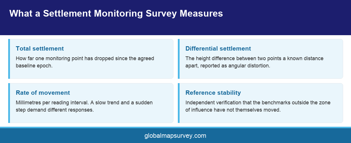
Settlement is downward movement of a structure or of the ground beneath it. A monitoring survey quantifies that movement by fixing permanent points on the structure, tying them to reference points that sit outside the zone of influence, and re measuring the height difference between them on a repeating cycle. The number that matters is never the absolute level. It is the change in level between one epoch and the next.
That distinction drives the whole design of the programme. If the reference points move, every reading is wrong in the same direction and the error is invisible in the data. Good practice in the Emirates places reference benchmarks well away from the excavation, ties them into an established survey control network, and re verifies them independently at intervals so that any drift is caught rather than absorbed.
The survey also distinguishes between the total amount a structure has settled and the difference between adjacent points. Uniform settlement rarely damages a building. Differential settlement does, because it puts the frame into distortion it was never designed to carry.
Total Settlement Against Differential Settlement
Total settlement is how far a single point has dropped since the baseline. Differential settlement is the difference between two points a known distance apart, usually expressed as angular distortion. Structural damage correlates far better with angular distortion than with total movement, which is why a monitoring report that quotes only maximum settlement is incomplete. Typical engineering practice treats an angular distortion around one in five hundred as the point at which cracking becomes likely in a framed building, and roughly one in three hundred as the point at which serviceability is at risk. Those are indicative bands. The project structural engineer sets the numbers that apply.
What a Monitoring Point Looks Like
A monitoring point is a permanent, repeatable, uniquely identified target. On a concrete frame it is often a stainless steel socket grouted into a column at a consistent height. On a facade it may be a reflective prism or a survey nail. Whatever the type, three properties matter. It must not move relative to the structure. It must be observable from the same setup every time. It must be protected from site traffic, because a point knocked out of position halfway through a programme destroys the record that came before it and the record that follows.
When UAE Projects Need Settlement Monitoring
Four situations account for most monitoring commissions in the Emirates. The first is deep excavation next to an existing building, where removing lateral support draws the neighbouring ground down and in. The second is new build on reclaimed or sabkha ground, where the compressible layer beneath the fill continues to consolidate for years after handover. The third is dewatering, which lowers the water table across a wider footprint than most people expect and settles anything founded above the drawdown cone. The fourth is a structure that has already shown distress, where monitoring is used to decide whether the movement is finished or still running.
Contract and consent conditions drive a fifth category. Where a project sits close to a metro alignment, a utility corridor, a port asset or a rail reserve, the asset owner will usually require a monitoring regime as a condition of working nearby. The specification in those cases is written by the asset owner and the survey contractor must meet it exactly rather than propose an equivalent.
Timing is where owners most often lose value. Monitoring that starts after excavation has begun has no baseline, and without a baseline the survey can describe the shape of the movement but not its size. A programme should be mobilised early enough to capture at least two independent baseline epochs while the site is still undisturbed, so that instrument noise can be separated from real movement before anything happens on site.
Adjacent owner risk deserves its own mention. Where works run alongside a third party building, a dilapidation survey recorded before mobilisation and settlement monitoring run through the works are complementary rather than alternative. One establishes the pre existing condition. The other proves whether the works changed it.
Ground conditions along the Gulf coast make the case for early mobilisation stronger than it is in many markets. Coastal sabkha, loose calcareous sand and a high water table combine to produce settlement behaviour that is both larger and slower than an inland site of the same footprint would show. Compressible layers under reclamation fill can continue consolidating for years, which means a programme scoped to end at practical completion often stops measuring exactly when the useful part of the curve begins. Scope the duration from the ground model, not from the construction programme.
Setting Trigger Levels That Actually Trigger Something
A trigger level is a movement threshold tied to a defined action. Most UAE monitoring specifications use three bands. Green means continue as planned. Amber means increase reading frequency, notify the engineer and review the method statement. Red means stop, secure the excavation and convene the design team. The bands are useless unless the action attached to each one is written down and someone is named as responsible for taking it.
Thresholds are derived from the structural assessment, not from the survey. The structural engineer calculates how much movement the building can absorb before serviceability or capacity is affected, then applies a factor of safety to set the red line. Amber is normally placed at a value that gives enough warning time to intervene, often around two thirds of red. Green is everything below amber.
Rate matters as much as magnitude. A structure that has settled a few millimetres over six months is behaving differently from one that settled the same amount in a week, even though both readings sit in the same band. Well written specifications therefore carry a rate trigger alongside the absolute trigger, expressed as movement per reading interval.
International guidance is a useful sense check when a specification is being drafted from scratch. The damage classification work summarised by bodies such as the Institution of Civil Engineers community and its published guidance and the structural serviceability literature both frame tolerable movement in terms of distortion rather than absolute drop, and both stress that masonry and framed structures behave very differently at the same numeric value. Specifications that copy a threshold from a previous project without checking the structural form behind it are the most common source of nuisance alarms.
One more practical point. Trigger levels should be reviewed, not frozen. If the first six weeks of data show measurement scatter tighter than assumed, the amber band can often be brought in to give earlier warning. If the structure proves stiffer than modelled, the red line may safely relax. Build a review point into the specification so that the thresholds improve as the evidence accumulates.
Who Signs the Thresholds Off
The survey contractor should not set trigger levels alone. The values belong to the structural engineer of record, who understands the frame, the foundation design and the assumptions behind them. The surveyor advises on whether the proposed thresholds are larger than the measurement uncertainty of the chosen method, which is a real constraint. A threshold set below what the instrument can reliably resolve produces false alarms, and false alarms train a site to ignore the system. Agreement between the two disciplines, recorded in the monitoring specification and signed before mobilisation, is what makes the regime defensible later.
Writing the Escalation Chain
Every threshold needs a named recipient, a contact route and a response time. In practice the chain runs from the monitoring surveyor to the site engineer, from the site engineer to the structural engineer, and from there to the client and any affected third party. Set out who is called at amber and who is called at red, how quickly, and by what means. A monitoring report that sits unread in an inbox for three days has failed even if every measurement in it was correct. Clarity here is what turns measurement into control.
Instruments and Methods Across a Monitoring Programme
Method selection is a trade between accuracy, cost, access and how quickly a result is needed. A note on deformation monitoring survey may use one method or several in combination, and the right answer changes as a project moves from excavation into superstructure.
Precise Levelling
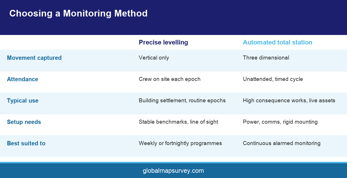
Digital precise levelling with an invar staff remains the reference method for vertical movement and still answers most building settlement questions in the Emirates. It delivers sub millimetre repeatability over a closed loop, it is independent of any electronic reference frame, and its error behaviour is well understood. Its limitations are practical rather than technical. It needs line of sight, it needs a person on site, and it produces vertical movement only. For a building settlement programme with weekly or fortnightly epochs, those limitations rarely bite.
Automated Total Stations
A motorised total station installed in a fixed housing observes an array of prisms on a timed cycle and reports without anyone attending site. It gives movement in three dimensions rather than one, which matters where lateral movement of a retaining wall is as important as settlement. Automated systems suit long duration, high consequence works such as excavation next to an operating asset. They cost more to install and they need power, communications and a stable mounting, so they are usually reserved for the situations that justify them.
Satellite and Remote Methods
GNSS gives continuous three dimensional position at points with clear sky view and suits large structures and ground movement across a wide area. Satellite radar interferometry can reveal regional settlement patterns across a district without any site installation at all, which makes it a useful screening tool. Neither replaces levelling for the millimetre level questions asked of a building. In a well designed programme they sit alongside conventional observation rather than in place of it.
Baseline, Frequency and the Discipline of Repetition
A monitoring programme is only as good as its baseline. Two independent epochs observed before any construction activity, ideally on separate days and by separate setups, establish both the starting value and the natural scatter of the measurement. Everything reported afterwards is a difference from that baseline, so an error in it propagates through the whole record.
Reading frequency should follow the risk, and the risk changes. During bulk excavation and dewatering, weekly or even daily epochs are normal. Once the basement slab is cast and the excavation is propped, fortnightly is often enough. Through superstructure loading the interval may tighten again as load arrives. After practical completion, monitoring usually continues at monthly then quarterly intervals until two or three consecutive epochs show the movement has stabilised.
The single most valuable discipline is consistency. Same instrument, same observer where possible, same route, same reference points, same time of day. Heat shimmer across an Abu Dhabi site at midday will degrade a levelling run measurably, so early morning observation is not a preference but a method control. Changing anything mid programme introduces a step in the data that looks exactly like real movement and takes weeks to unpick.
Every epoch should close. A levelling loop that returns to its start with a misclosure inside the stated tolerance is self checking evidence that the run is sound. A loop that does not close should be re observed rather than adjusted into acceptability, and the raw record should show both.
Weather and site conditions belong in the record too. Refraction across a hot surface, wind on a staff and vibration from nearby plant all degrade a reading in ways that are invisible once the number reaches a spreadsheet. Noting conditions at each epoch costs nothing and repeatedly explains anomalies that would otherwise be read as movement. The principle behind it is the same one that governs any repeated geodetic observation, which is that the measurement and the conditions under which it was taken are a single piece of information.
What an Owner Should Receive
The deliverable set from structural settlement survey services should be specified before award, because the reporting is what the client actually buys. At minimum an epoch report carries the observation date and time, the instrument and its calibration status, the observer, the reference points used and their verification status, the raw and adjusted values, the movement since baseline, the movement since the previous epoch, the misclosure achieved and a clear statement of which points sit in which trigger band.
Alongside the tabulated numbers, a cumulative movement plot per point is what makes a monitoring record readable. Trends are visible in a graph long before they are obvious in a table, and the shape of the curve carries information that the latest number does not. A settlement curve that is flattening tells a different story from one that is still steepening at the same magnitude.
For programmes running more than a few months, a rolling summary that plots all points on a common axis against the trigger bands earns its place. It gives the project manager one page that answers the only question they usually have, which is whether anything is moving faster than expected.
Finally, the data should be handed over in a form that outlives the contract. A spreadsheet or processed survey data export with point identifiers, coordinates, dates and values lets the owner reopen the record years later. A set of PDF reports alone does not.
Two reporting habits separate a useful monitoring service from a compliant one. The first is a short written interpretation alongside the numbers, saying in plain language what the surveyor believes the data shows and what they expect next. The second is an explicit statement when nothing has happened. A report that says movement remains within instrument noise and no point has left the green band is far more valuable to a project manager than a table they have to interpret themselves, and it creates a dated record that the structure was checked and found stable.
Appointing a Monitoring Contractor in Abu Dhabi
The commercial question owners ask is who offers the best settlement monitoring survey in Abu Dhabi. The useful question is narrower. Can this contractor demonstrate the accuracy they claim, will the same crew return each epoch, and what happens on the day a reading crosses amber.
Ask for a worked example of a closed levelling loop from a live project, with the misclosure visible. Ask how reference points are verified and how often. Ask who is on call when a trigger is breached and how fast the client hears about it. Ask what happens if a monitoring point is destroyed by site traffic, because on a busy site it will be. Those four answers separate a genuine monitoring capability from a company that owns a level.
Mobilisation speed is the other differentiator that owners underrate. Monitoring is frequently commissioned late, after a neighbouring owner has objected or a crack has been noticed, and at that point the value of the survey decays by the day. A contractor with instruments, calibrated staves and trained observers already in the Emirates can install points and capture a first epoch inside a working week. One assembling a crew for the job cannot. Ask directly how quickly a baseline can be on the ground, and treat the answer as part of the technical evaluation rather than the commercial one.
Continuity is worth paying for. A monitoring record produced by four different crews using three different routes is far harder to defend than one produced consistently, and consistency is a resourcing commitment rather than a technical one. Ask how it will be guaranteed across the programme duration, and get the answer in writing.
Look at the survey side of the appointment as well as the monitoring side. A contractor that also runs construction survey work on the same project can tie monitoring points into the same control framework as the setting out, which removes a whole class of reconciliation problems later. Where the two scopes sit with different companies, agree at the outset whose datum governs and how the two networks will be tied together.
Quality management matters here more than in most survey work, because the output is evidence. A contractor operating a documented quality management system with calibration records, method statements and a defined checking regime can show why a number should be believed. On a project where monitoring data may end up in a claim, that provenance is the product.
Conclusion
A settlement monitoring survey in UAE succeeds or fails on decisions taken before the first reading. Fix the reference frame outside the zone of influence, capture two clean baseline epochs, agree trigger levels and the actions attached to them with the structural engineer, then repeat the same observation with the same discipline for as long as the risk lasts. Get those right and the data will answer the question the project needs answered. To scope a monitoring programme for a project in Abu Dhabi or Dubai, talk to the Global Maps Survey monitoring team.
AN ISO 9001-2015 CERTIFIED COMPANY