Home \ Blog \ Geographic Survey in Abu Dhabi: A Complete Guide
Geographic Survey in Abu Dhabi: A Complete Guide
June 16, 2026
Geographic survey in Abu Dhabi plays a critical role in shaping the emirate’s rapidly growing infrastructure and construction landscape. From large-scale urban development projects to precise boundary mapping, geographic surveys provide the spatial data foundation that engineers, developers, and planners rely on. Whether you are managing a construction project, planning land development, or working on civil infrastructure, understanding how geographic surveys work in Abu Dhabi is essential. This guide walks you through the key methods, technologies, applications, and benefits of professional geographic surveying in the region.
Key Takeaways
- Geographic survey in Abu Dhabi supports infrastructure, construction, and land development projects by delivering accurate spatial data.
- Geographic survey in UAE uses modern technologies like GPS, LiDAR, and drone-based mapping to collect precise measurements.
- Professional surveying services improve project planning accuracy, reduce costly errors, and ensure compliance with land development regulations.
What Is a Geographic Survey and Why Does It Matter in Abu Dhabi?
A geographic survey is the process of measuring and mapping physical features of land, including elevation, boundaries, structures, and natural formations. It provides the spatial data needed to plan, design, and execute construction and infrastructure projects.
In Abu Dhabi, where large-scale urban expansion and infrastructure investment are ongoing, the demand for accurate geographic surveys is consistently high. From road networks and utilities to commercial developments and waterfront projects, every project requires reliable spatial data to move forward efficiently.
According to the UAE Space Policy, geospatial information is recognized as a strategic national resource. This reflects how deeply geographic surveys are embedded in the UAE’s development agenda, making professional surveying services an indispensable part of any project lifecycle.
Key Types of Geographic Surveys Used in Abu Dhabi
Different projects in Abu Dhabi require different types of geographic surveys. Understanding which survey type applies to your project helps ensure the right data is collected efficiently.
Topographic Surveys
A topographic survey maps the natural and man-made features of a site, including elevation contours, vegetation, water bodies, roads, and existing structures. It gives project teams a detailed picture of the site’s physical characteristics before any design or construction begins.
In Abu Dhabi’s mixed terrain, where flat desert areas meet coastal zones and developed urban districts, topographic surveys are essential. They help engineers and architects design structures that account for land elevation changes, drainage patterns, and surface conditions. For large infrastructure projects like highways or utility networks, topographic data directly influences route planning and design decisions.
Boundary Surveys
Boundary surveys define the legal limits of a parcel of land. They establish where one property ends and another begins, using recorded deeds, legal descriptions, and physical markers.
For real estate developers and land management agencies in Abu Dhabi, boundary surveys are critical for avoiding ownership disputes and ensuring compliance with municipal regulations. Before any construction begins, confirming the exact legal boundaries of a site prevents costly legal conflicts and project delays. Boundary surveys also support land registration processes managed by Abu Dhabi’s municipal and land authorities.
Engineering and Construction Surveys
Engineering surveys support the design and construction phases of infrastructure projects. They include setting out the precise positions of buildings, roads, utilities, and other structures on a site.
Construction surveys ensure that structures are built exactly where they are planned, reducing the risk of misalignment, structural errors, or regulatory non-compliance. In Abu Dhabi’s high-value construction environment, precision is non-negotiable. Even minor positional errors can result in significant rework costs or safety risks. Professional engineering surveys reduce these risks significantly.
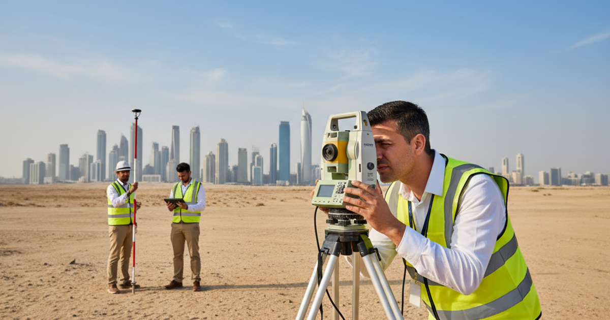
Technologies Driving Geographic Survey in UAE
Modern geographic survey in UAE relies on advanced technologies that dramatically improve accuracy, speed, and data quality compared to traditional manual methods.
- GPS and GNSS Systems: Global Navigation Satellite Systems provide real-time positioning data with centimetre-level accuracy, enabling surveyors to map large areas quickly.
- LiDAR (Light Detection and Ranging): LiDAR uses laser pulses to create highly detailed 3D point clouds of terrain and structures, useful for complex topographic mapping.
- Drone-Based Aerial Surveys: Unmanned aerial vehicles (UAVs) equipped with cameras and sensors capture high-resolution aerial imagery and photogrammetric data efficiently over large areas.
- Total Stations and Digital Theodolites: These instruments measure angles and distances with high precision, commonly used in engineering and boundary surveys.
- GIS (Geographic Information Systems): GIS platforms integrate multiple data layers to visualize, analyze, and manage spatial information for planning and decision-making purposes.
These technologies collectively enable faster data collection, more detailed analysis, and improved project outcomes. For construction and infrastructure projects in Abu Dhabi, adopting modern surveying technology translates directly into better planning accuracy and reduced project risk. Authoritative geospatial guidance from organizations like the International Federation of Surveyors (FIG) continues to shape best practices for these technologies globally.
Applications of Geographic Survey in Abu Dhabi’s Infrastructure Sector
Geographic surveys serve a wide range of applications across Abu Dhabi’s fast-developing infrastructure and real estate sectors. Understanding where and how surveys are applied helps stakeholders appreciate their strategic importance.
Urban Planning and Land Development
Urban planners in Abu Dhabi use geographic survey data to make decisions about zoning, land use, and infrastructure placement. Accurate maps help identify where roads, buildings, parks, and utility networks should be positioned to maximize efficiency and livability.
Land developers also depend on geographic surveys before acquiring or developing properties. Survey data reduces the risk of purchasing land with undisclosed encumbrances, boundary disputes, or unsuitable terrain conditions. For large master-planned communities, which are common in Abu Dhabi, detailed geographic surveys inform every phase from initial site selection through to final construction.
Infrastructure and Civil Engineering Projects
Road networks, bridges, pipelines, and utility corridors all require detailed geographic surveys before construction begins. Engineers use survey data to design structures that account for site conditions, ensuring safety, functionality, and regulatory compliance.
For Abu Dhabi’s ongoing investment in transportation infrastructure, including road expansions and public transit networks, geographic surveys provide the spatial foundation for project planning. Surveying data also supports environmental impact assessments and utility conflict analysis, which are critical steps in complex infrastructure approvals.
Real Estate and Property Development
Real estate developers in Abu Dhabi rely on geographic surveys to understand the physical characteristics and legal boundaries of development sites. Survey data informs building placement, setback requirements, and site access planning.
Accurate geographic surveys also support property valuation and mortgage processes. Financial institutions and investors require verified spatial data to assess a property’s true boundaries and any encumbrances that might affect its value or usability.
How to Choose a Professional Geographic Survey Provider in Abu Dhabi
Selecting the right survey provider is as important as the survey itself. The quality of geographic data directly impacts every downstream decision made by engineers, developers, and planners.
- Verify technical expertise: Confirm the provider has experience with the specific survey type your project requires, whether topographic, boundary, or engineering surveys.
- Check equipment and technology: A reliable provider uses modern surveying instruments and data processing software to ensure accuracy.
- Review project experience: Look for providers with a demonstrated track record on projects similar in scope and complexity to yours in Abu Dhabi or the UAE.
- Assess data delivery capabilities: Ensure the provider can deliver data in formats compatible with your engineering or GIS software platforms.
- Understand reporting standards: Professional survey reports should meet local regulatory requirements and include clearly documented methodologies.
Partnering with an experienced provider who understands Abu Dhabi’s regulatory landscape and physical terrain reduces the risk of inaccurate data that could compromise project timelines or budgets.
Conclusion
Geographic survey in Abu Dhabi is a foundational service for any construction, infrastructure, or land development project. From topographic and boundary surveys to drone-based mapping and GIS integration, modern surveying technologies deliver the precision and detail that complex projects demand. As Abu Dhabi continues to develop its urban environment and infrastructure network, the importance of accurate geographic data only grows. Whether you are a developer, engineer, or planner, working with a professional survey provider ensures your project starts with reliable, actionable spatial data. To learn more about professional surveying and mapping solutions, visit Global Map Survey and explore how expert geographic survey services can support your next project in Abu Dhabi or anywhere across the UAE.
Frequently Asked Questions
What is a geographic survey in Abu Dhabi?
A geographic survey in Abu Dhabi is the process of measuring and mapping land features, boundaries, and elevations. It provides accurate spatial data used by engineers, developers, and planners to support construction and infrastructure projects across the emirate.
Why is geographic survey important for construction projects in Abu Dhabi?
Geographic surveys provide the spatial foundation that construction teams need to design and build accurately. Without reliable survey data, projects risk structural misalignment, boundary disputes, and regulatory non-compliance, all of which lead to costly delays and rework on Abu Dhabi construction sites.
What types of geographic surveys are commonly used in the UAE?
Common geographic survey types in the UAE include topographic surveys, boundary surveys, engineering surveys, and construction surveys. Each serves a specific purpose, from mapping terrain and defining legal boundaries to supporting structural design and precise on-site positioning during construction phases.
What technologies are used in geographic survey in UAE?
Geographic survey in UAE uses GPS and GNSS systems, LiDAR, drone-based aerial mapping, total stations, and GIS platforms. These technologies improve data accuracy, speed up field data collection, and enable detailed spatial analysis for infrastructure and development projects.
How long does a geographic survey take in Abu Dhabi?
The duration of a geographic survey in Abu Dhabi depends on the site size, terrain complexity, and survey type required. Small boundary surveys may take a few days, while large topographic or engineering surveys for major infrastructure projects can require several weeks of fieldwork and data processing.
Who needs geographic survey services in Abu Dhabi?
Construction companies, civil engineering firms, real estate developers, infrastructure planners, government agencies, and architects all require geographic survey services in Abu Dhabi. Accurate spatial data is essential for anyone involved in land development, property registration, or infrastructure design and construction.
How does a topographic survey differ from a boundary survey?
A topographic survey maps physical features like elevation, terrain, and structures on a site. A boundary survey defines the legal limits of a land parcel. Both are important but serve different purposes, and many Abu Dhabi projects require both types at different project stages.
Can drone surveys replace traditional geographic surveys in Abu Dhabi?
Drone surveys complement but do not fully replace traditional geographic surveys. They are highly effective for large-area aerial mapping and topographic data collection. However, boundary surveys and engineering set-out work still require ground-based instruments for the precision levels that Abu Dhabi regulations demand.
How do I find a reliable geographic survey provider in Abu Dhabi?
Look for providers with demonstrated project experience, modern surveying equipment, and familiarity with Abu Dhabi’s regulatory requirements. Global Map Survey’s services page details professional land surveying and geospatial solutions that support construction and infrastructure projects with accurate spatial data.
What is the role of GIS in geographic survey in Abu Dhabi?
GIS platforms integrate multiple layers of spatial data from geographic surveys, enabling planners and engineers to visualize, analyze, and manage land information effectively. In Abu Dhabi, GIS supports urban planning, infrastructure routing, and land management decisions across all major development sectors.
AN ISO 9001-2015 CERTIFIED COMPANY