


How to Choose the Right Land Surveying Company in UAE
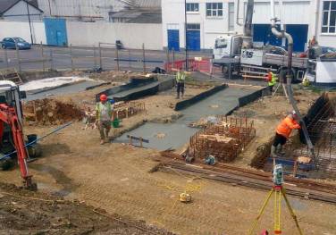
Choosing the right land surveying company in UAE can determine the success of your construction or infrastructure project. From boundary verification to topographic mapping, professional surveying lays the groundwork for accurate planning. Whether you are developing a residential complex in Dubai or managing a civil engineering project in Abu Dhabi, reliable survey data is non-negotiable. […]
Discover MoreTopographic survey and Mapping
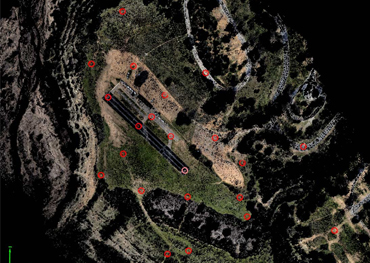
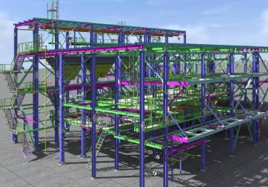
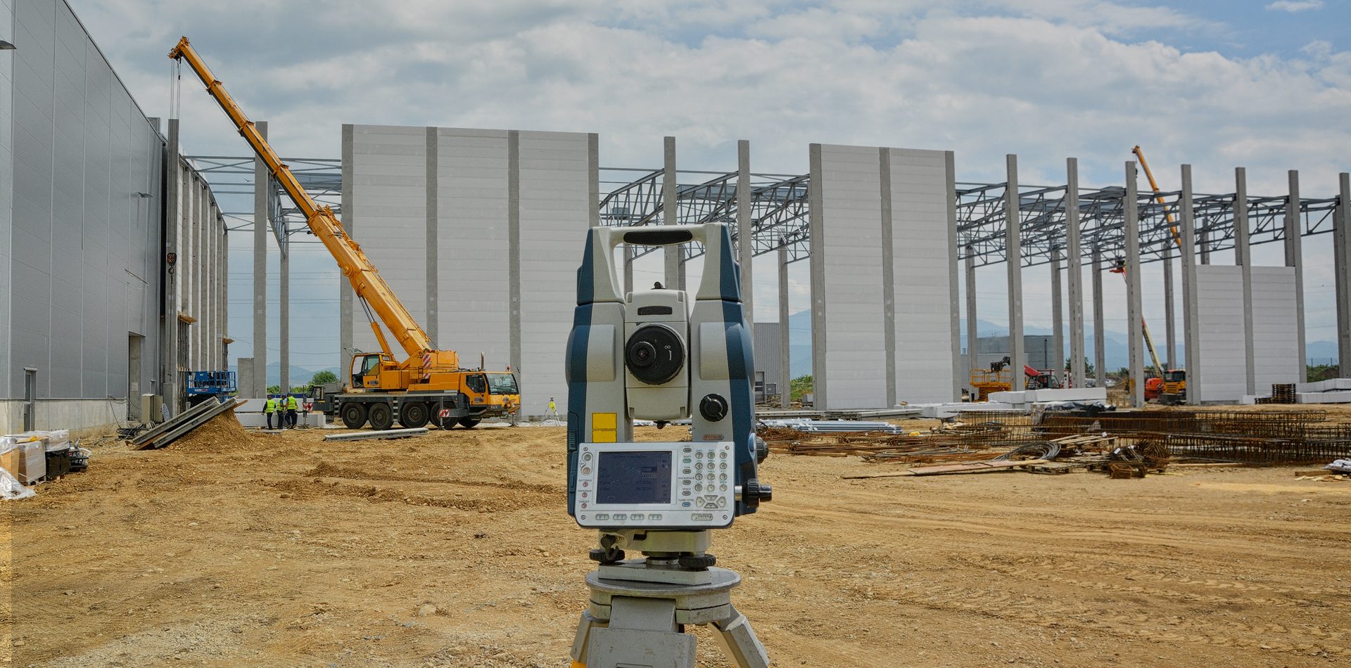
Topographic survey and Mapping Contour mapping Establishing survey control networks Geographic Survey Demarcation/Boundary pegging services Precise levelling Construction surveys Pre-construction services Project management-Site control Establishment of gridlines and datum Profile levelling & Cross-section Surveys Gate-level Computation Services Measured building surveys As-built surveys Survey Contracting and Consultancy Setting out services Digitisation Data processing GIS Mapping Project […]
Discover More
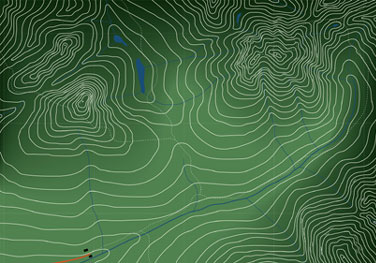
Contour mapping
Topographic survey and Mapping Contour mapping Establishing survey control networks Geographic Survey Demarcation/Boundary pegging services Precise levelling Construction surveys Pre-construction services Project management-Site control Establishment of gridlines and datum Profile levelling & Cross-section Surveys Gate-level Computation Services Measured building surveys As-built surveys Survey Contracting and Consultancy Setting out services Digitisation Data processing GIS Mapping Project […]
Discover MoreEstablishing survey control networks
Topographic survey and Mapping Contour mapping Establishing survey control networks Geographic Survey Demarcation/Boundary pegging services Precise levelling Construction surveys Pre-construction services Project management-Site control Establishment of gridlines and datum Profile levelling & Cross-section Surveys Gate-level Computation Services Measured building surveys As-built surveys Survey Contracting and Consultancy Setting out services Digitisation Data processing GIS Mapping Project […]
Discover More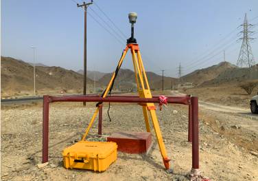

Geographic Survey
Topographic survey and Mapping Contour mapping Establishing survey control networks Geographic Survey Demarcation/Boundary pegging services Precise levelling Construction surveys Pre-construction services Project management-Site control Establishment of gridlines and datum Profile levelling & Cross-section Surveys Gate-level Computation Services Measured building surveys As-built surveys Survey Contracting and Consultancy Setting out services Digitisation Data processing GIS Mapping Project […]
Discover MoreDemarcation/Boundary pegging services
Topographic survey and Mapping Contour mapping Establishing survey control networks Geographic Survey Demarcation/Boundary pegging services Precise levelling Construction surveys Pre-construction services Project management-Site control Establishment of gridlines and datum Profile levelling & Cross-section Surveys Gate-level Computation Services Measured building surveys As-built surveys Survey Contracting and Consultancy Setting out services Digitisation Data processing GIS Mapping Project […]
Discover More

Precise levelling
Topographic survey and Mapping Contour mapping Establishing survey control networks Geographic Survey Demarcation/Boundary pegging services Precise levelling Construction surveys Pre-construction services Project management-Site control Establishment of gridlines and datum Profile levelling & Cross-section Surveys Gate-level Computation Services Measured building surveys As-built surveys Survey Contracting and Consultancy Setting out services Digitisation Data processing GIS Mapping Project […]
Discover MoreConstruction surveys
Topographic survey and Mapping Contour mapping Establishing survey control networks Geographic Survey Demarcation/Boundary pegging services Precise levelling Construction surveys Pre-construction services Project management-Site control Establishment of gridlines and datum Profile levelling & Cross-section Surveys Gate-level Computation Services Measured building surveys As-built surveys Survey Contracting and Consultancy Setting out services Digitisation Data processing GIS Mapping Project […]
Discover More

Pre-construction services
Topographic survey and Mapping Contour mapping Establishing survey control networks Geographic Survey Demarcation/Boundary pegging services Precise levelling Construction surveys Pre-construction services Project management-Site control Establishment of gridlines and datum Profile levelling & Cross-section Surveys Gate-level Computation Services Measured building surveys As-built surveys Survey Contracting and Consultancy Setting out services Digitisation Data processing GIS Mapping Project […]
Discover MoreProject management-Site control
Topographic survey and Mapping Contour mapping Establishing survey control networks Geographic Survey Demarcation/Boundary pegging services Precise levelling Construction surveys Pre-construction services Project management-Site control Establishment of gridlines and datum Profile levelling & Cross-section Surveys Gate-level Computation Services Measured building surveys As-built surveys Survey Contracting and Consultancy Setting out services Digitisation Data processing GIS Mapping Project […]
Discover More
Establishment of gridlines and datum
Topographic survey and Mapping Contour mapping Establishing survey control networks Geographic Survey Demarcation/Boundary pegging services Precise levelling Construction surveys Pre-construction services Project management-Site control Establishment of gridlines and datum Profile levelling & Cross-section Surveys Gate-level Computation Services Measured building surveys As-built surveys Survey Contracting and Consultancy Setting out services Digitisation Data processing GIS Mapping Project […]
Discover MoreProfile levelling & Cross-section Surveys
Topographic survey and Mapping Contour mapping Establishing survey control networks Geographic Survey Demarcation/Boundary pegging services Precise levelling Construction surveys Pre-construction services Project management-Site control Establishment of gridlines and datum Profile levelling & Cross-section Surveys Gate-level Computation Services Measured building surveys As-built surveys Survey Contracting and Consultancy Setting out services Digitisation Data processing GIS Mapping Project […]
Discover More

Gate-level Computation Services
Topographic survey and Mapping Contour mapping Establishing survey control networks Geographic Survey Demarcation/Boundary pegging services Precise levelling Construction surveys Pre-construction services Project management-Site control Establishment of gridlines and datum Profile levelling & Cross-section Surveys Gate-level Computation Services Measured building surveys As-built surveys Survey Contracting and Consultancy Setting out services Digitisation Data processing GIS Mapping Project […]
Discover MoreMeasured building surveys
Topographic survey and Mapping Contour mapping Establishing survey control networks Geographic Survey Demarcation/Boundary pegging services Precise levelling Construction surveys Pre-construction services Project management-Site control Establishment of gridlines and datum Profile levelling & Cross-section Surveys Gate-level Computation Services Measured building surveys As-built surveys Survey Contracting and Consultancy Setting out services Digitisation Data processing GIS Mapping Project […]
Discover More

As-built surveys
Topographic survey and Mapping Contour mapping Establishing survey control networks Geographic Survey Demarcation/Boundary pegging services Precise levelling Construction surveys Pre-construction services Project management-Site control Establishment of gridlines and datum Profile levelling & Cross-section Surveys Gate-level Computation Services Measured building surveys As-built surveys Survey Contracting and Consultancy Setting out services Digitisation Data processing GIS Mapping Project […]
Discover MoreSurvey Contracting and Consultancy
Topographic survey and Mapping Contour mapping Establishing survey control networks Geographic Survey Demarcation/Boundary pegging services Precise levelling Construction surveys Pre-construction services Project management-Site control Establishment of gridlines and datum Profile levelling & Cross-section Surveys Gate-level Computation Services Measured building surveys As-built surveys Survey Contracting and Consultancy Setting out services Digitisation Data processing GIS Mapping Project […]
Discover More

Setting out services
Topographic survey and Mapping Contour mapping Establishing survey control networks Geographic Survey Demarcation/Boundary pegging services Precise levelling Construction surveys Pre-construction services Project management-Site control Establishment of gridlines and datum Profile levelling & Cross-section Surveys Gate-level Computation Services Measured building surveys As-built surveys Survey Contracting and Consultancy Setting out services Digitisation Data processing GIS Mapping Project […]
Discover MoreDigitisation
Topographic survey and Mapping Contour mapping Establishing survey control networks Geographic Survey Demarcation/Boundary pegging services Precise levelling Construction surveys Pre-construction services Project management-Site control Establishment of gridlines and datum Profile levelling & Cross-section Surveys Gate-level Computation Services Measured building surveys As-built surveys Survey Contracting and Consultancy Setting out services Digitisation Data processing GIS Mapping Project […]
Discover More

Data processing
Topographic survey and Mapping Contour mapping Establishing survey control networks Geographic Survey Demarcation/Boundary pegging services Precise levelling Construction surveys Pre-construction services Project management-Site control Establishment of gridlines and datum Profile levelling & Cross-section Surveys Gate-level Computation Services Measured building surveys As-built surveys Survey Contracting and Consultancy Setting out services Digitisation Data processing GIS Mapping Project […]
Discover MoreGIS Mapping
Topographic survey and Mapping Contour mapping Establishing survey control networks Geographic Survey Demarcation/Boundary pegging services Precise levelling Construction surveys Pre-construction services Project management-Site control Establishment of gridlines and datum Profile levelling & Cross-section Surveys Gate-level Computation Services Measured building surveys As-built surveys Survey Contracting and Consultancy Setting out services Digitisation Data processing GIS Mapping Project […]
Discover More

Project Consultancy & Technical Staff Supply
Topographic survey and Mapping Contour mapping Establishing survey control networks Geographic Survey Demarcation/Boundary pegging services Precise levelling Construction surveys Pre-construction services Project management-Site control Establishment of gridlines and datum Profile levelling & Cross-section Surveys Gate-level Computation Services Measured building surveys As-built surveys Survey Contracting and Consultancy Setting out services Digitisation Data processing GIS Mapping Project […]
Discover MoreEngineering Setout
Topographic survey and Mapping Contour mapping Establishing survey control networks Geographic Survey Demarcation/Boundary pegging services Precise levelling Construction surveys Pre-construction services Project management-Site control Establishment of gridlines and datum Profile levelling & Cross-section Surveys Gate-level Computation Services Measured building surveys As-built surveys Survey Contracting and Consultancy Setting out services Digitisation Data processing GIS Mapping Project […]
Discover More