
Home \ Blog \ 6 Benefits of Accurate Underground Utility Mapping for Infrastructure Projects
6 Benefits of Accurate Underground Utility Mapping for Infrastructure Projects
July 15, 2026
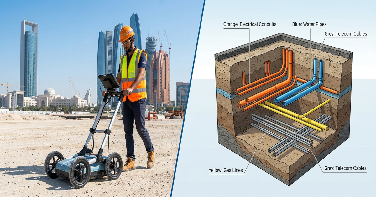
Underground utility mapping is no longer optional for modern infrastructure projects. Every time a construction crew breaks ground without verified underground data, they risk striking buried cables, pipes, or conduits. The consequences range from costly project delays to life-threatening accidents. In regions where large-scale infrastructure development is accelerating, accurate underground utility mapping has become a critical first step before any excavation or civil engineering work begins. This blog explores six key benefits that make utility mapping essential for every project.
Key Takeaways
- A thorough utility mapping survey prevents utility strikes and protects workers on site.
- GPR surveys and radio detection surveys provide subsurface data without invasive digging.
- Accurate mapping reduces unexpected project costs and supports better infrastructure planning across all project phases.
What Is Underground Utility Mapping and Why Does It Matter?
Underground utility mapping is the process of identifying, locating, and recording the position of buried utilities such as gas lines, water mains, electrical cables, and telecommunications infrastructure. It combines non-invasive survey technologies with spatial data analysis to create a detailed picture of what lies beneath a site.
Rapid urban growth in many regions means utility networks are dense and often poorly documented. A precise utility mapping survey using technologies like ground-penetrating radar gives project teams the subsurface intelligence they need to plan safely and efficiently. Without this data, teams are essentially working blind underground, which creates serious risks for workers, communities, and project budgets. Partnering with experienced professionals who offer comprehensive survey and mapping services ensures the highest standard of underground investigation from the outset.
According to the American Society of Civil Engineers, utility strikes during excavation are among the most common causes of construction delays and accidents globally. Preventing these incidents starts with knowing exactly what is buried and where.
Benefit 1: Prevention of Utility Strikes During Excavation
One of the most immediate and critical benefits of accurate underground utility mapping is the prevention of accidental utility strikes. A single strike on a high-voltage cable or a pressurized gas line can result in explosions, service outages, injuries, or fatalities.
A professional utility mapping survey identifies the exact depth, direction, and type of every buried utility before excavation begins. Technologies such as radio detection surveys use electromagnetic signals to trace metallic pipes and cables underground with high precision. Combined with GPR surveys, teams can detect both metallic and non-metallic utilities. This dual-technology approach significantly reduces the risk of accidental damage, keeping workers and the surrounding community safe. For projects that also require subsurface drainage assessment, integrating professional drainage surveys alongside utility mapping delivers a more complete picture of underground conditions. Professional teams also rely on utility mapping services that combine multiple detection methods to maximize coverage across complex sites.
Benefit 2: Improved On-Site Safety Through Professional Utility Survey Services
Worker safety is a non-negotiable priority on any construction site. Subsurface hazards are invisible and unpredictable without proper mapping data. When workers excavate near unmapped utilities, even minor miscalculations can lead to serious accidents.
Accurate utility survey services create a verified record of all underground assets before any ground disturbance occurs. This information is shared with excavation crews as part of a comprehensive site safety plan. Project managers can define exclusion zones around high-risk utilities and plan dig routes that avoid dangerous areas. The result is a measurable reduction in on-site incidents and a stronger safety culture across the project team. Proper underground utility mapping also protects the public by preventing disruptions to essential services like water and electricity. Where structural risks near buried assets are a concern, structural settlement surveys can complement utility mapping to identify ground movement hazards before excavation begins.
Benefit 3: Reduction in Project Delays and Downtime
Unexpected utility encounters during excavation are among the most common causes of project delays in infrastructure work. When a buried utility is discovered mid-excavation, the team must stop all work while engineers investigate, reroute plans, and coordinate with utility providers. This unplanned downtime can add days or weeks to a project timeline.
A comprehensive utility mapping survey completed before works begin gives project managers the data they need to plan routes and methods that avoid subsurface conflicts. Site investigation surveys play a key role here by combining utility detection with ground condition assessments. When teams know what to expect underground, scheduling becomes more reliable and project milestones are met with greater consistency. This benefit has a direct positive impact on client satisfaction and contractor reputation. Integrating findings from GPR surveys into the pre-construction phase further strengthens schedule confidence by capturing data on both metallic and non-metallic buried assets.
Research from the Institution of Civil Engineers confirms that pre-construction subsurface investigations significantly reduce construction delays caused by unexpected utility conflicts.
Benefit 4: Lower Project Costs Through Utility Survey Services
Budget overruns are a persistent challenge in infrastructure development. Many of these overruns trace back to unforeseen underground conditions that were not identified during the planning phase. Repairs to damaged utilities, emergency rerouting, legal claims, and service restoration can cost significantly more than the original mapping investment.
Investing in utility survey services upfront gives project teams reliable data to make informed decisions about design, routing, and construction methods. This reduces the likelihood of costly surprises during execution. Accurate underground utility mapping data also allows engineers to choose more efficient construction techniques, such as trenchless methods, which are less disruptive and more cost-effective when utility positions are well understood. Teams working on road infrastructure can also benefit from complementary earthwork estimation and cut-and-fill analysis to further control project expenditure. Over the full project lifecycle, the return on investment from accurate utility mapping is substantial.
Benefit 5: Better Infrastructure Planning and Design Accuracy
Infrastructure projects increasingly involve complex underground networks that must coexist with new installations. Poor subsurface data leads to design conflicts, clashes between new and existing utilities, and expensive redesign work during construction.
A detailed utility mapping survey provides engineers and designers with accurate spatial data they can integrate directly into BIM (Building Information Modelling) platforms and CAD design tools. Radio detection surveys and GPR data together produce georeferenced utility maps that reflect real-world conditions. This level of accuracy supports clash detection in the design phase, long before a single shovel enters the ground. Better planning leads to more efficient designs, optimized utility corridor layouts, and reduced need for on-site design modifications. Topographic data gathered through topographic survey and mapping can be layered with utility map outputs to give design teams a fully integrated view of above-ground and below-ground conditions. Where structural monitoring is also a concern, deformation monitoring services complement utility mapping by tracking ground movement risks throughout the construction period.
Benefit 6: Regulatory Compliance and Risk Management
Infrastructure projects are subject to strict regulatory requirements from authorities managing public utilities and construction safety. Failing to conduct proper subsurface investigations before excavation can result in regulatory penalties, project stoppages, and liability for damages to utility providers.
Professional site investigation surveys help project teams demonstrate due diligence to regulatory bodies. A documented underground utility mapping survey forms part of the project risk management record, showing that all reasonable steps were taken to identify underground hazards before work began. This documentation is valuable during audits, disputes, or insurance claims. It also supports project handover documentation, giving asset owners a reliable record of what lies beneath completed infrastructure for future maintenance and expansion planning. For teams managing multiple site risks simultaneously, monitoring services can be integrated alongside utility mapping to maintain continuous oversight of ground conditions throughout the project lifecycle.
How GPR and Radio Detection Work Together for Maximum Accuracy in Underground Utility Mapping
No single survey technology can detect every type of underground utility in all soil conditions. A multi-technology approach delivers the most comprehensive and reliable results for complex infrastructure sites.
GPR surveys work by sending radar pulses into the ground and measuring reflections from buried objects, including non-metallic pipes, voids, and concrete structures. Radio detection surveys use electromagnetic induction to trace metallic utilities such as gas mains, water pipes, and power cables. When these two methods are combined as part of a full utility mapping survey, the coverage is comprehensive. The resulting data is processed and presented as georeferenced utility maps that engineering teams can use directly in planning and design workflows. This integrated approach reflects the highest standard of underground utility mapping practice and ensures that no buried asset goes undetected on a complex construction site.
Conclusion
Accurate utility mapping surveys deliver measurable benefits across every phase of an infrastructure project. From preventing dangerous utility strikes and improving worker safety to reducing delays, cutting costs, and supporting regulatory compliance, the value of reliable subsurface data cannot be overstated. Technologies like GPR surveys, radio detection surveys, and site investigation surveys form the foundation of responsible and efficient infrastructure delivery. For project teams looking to reduce risk and improve outcomes, professional utility survey services are the right investment from day one.
FAQ
Q1: What is an underground utility mapping survey?
Answer: An underground utility mapping survey is a professional subsurface investigation that identifies and records the position of buried utilities such as gas pipes, water mains, and electrical cables before excavation. It uses non-invasive technologies like GPR and radio detection to produce accurate underground maps for safe project planning.
Q2: How does a GPR survey work for detecting underground utilities?
Answer: A GPR survey sends high-frequency radar pulses into the ground and measures reflections from buried objects. It can detect both metallic and non-metallic utilities including plastic pipes, voids, and concrete structures, making it one of the most versatile tools in subsurface investigation available to construction teams.
Q3: What is the difference between a GPR survey and a radio detection survey?
Answer: A GPR survey detects all buried materials including non-metallic utilities, while radio detection surveys use electromagnetic signals specifically to trace metallic pipes and cables. Combining both methods provides the most complete and accurate picture of underground utility networks on any construction site.
Q4: Why are site investigation surveys important before construction?
Answer: Site investigation surveys assess ground conditions and underground utility positions before excavation begins. They help project teams avoid unexpected subsurface hazards, reduce costly delays, and meet regulatory requirements. This pre-construction data is essential for safe and efficient infrastructure project delivery in any region.
Q5: How do utility survey services reduce project costs?
Answer: Utility survey services provide accurate subsurface data that helps engineers design more efficient construction routes and methods. This prevents expensive utility strike repairs, emergency rerouting, and project downtime. Investing in professional utility surveys upfront typically results in significant cost savings throughout the entire project lifecycle.
Q6: Can underground utility mapping prevent accidents on construction sites?
Answer: Yes. Accurate underground utility mapping identifies the exact location of buried hazards before excavation begins. This allows project managers to define safety exclusion zones and plan dig routes around dangerous utilities, resulting in a measurable reduction in on-site accidents and protecting both workers and the surrounding community from preventable harm.
Q7: How accurate are radio detection surveys for locating buried cables?
Answer: Radio detection surveys are highly accurate for locating metallic utilities such as power cables and gas mains. Experienced surveyors using calibrated equipment can detect utilities at depths of several metres with strong positional accuracy. Results are most reliable when combined with GPR survey data for a complete subsurface picture.
Q8: What industries benefit most from utility mapping surveys?
Answer: Civil engineering firms, infrastructure developers, construction contractors, real estate developers, and government departments all benefit from utility mapping surveys. Any project involving ground excavation, pipeline installation, road construction, or building foundations requires reliable GPR and subsurface survey data to proceed safely and within budget.
Q9: How long does a utility mapping survey typically take on a construction site?
Answer: The duration of a utility mapping survey depends on site size, complexity of the underground network, and survey methods required. Small sites may be completed in a single day, while large infrastructure corridors may require several days of fieldwork. A professional survey team will provide a clear timeline during the initial project assessment.
Q10: Does underground utility mapping support BIM and CAD design workflows?
Answer: Yes. Data from a professional utility mapping survey is processed into georeferenced utility maps that integrate directly with BIM and CAD platforms, similar to how 3D laser scanning feeds spatial data into design models. This allows engineers to perform clash detection between new designs and existing underground assets during the design phase.
AN ISO 9001-2015 CERTIFIED COMPANY